workshop PostGIS Problem
What neighborhood and borough is Atlantic Commons in?
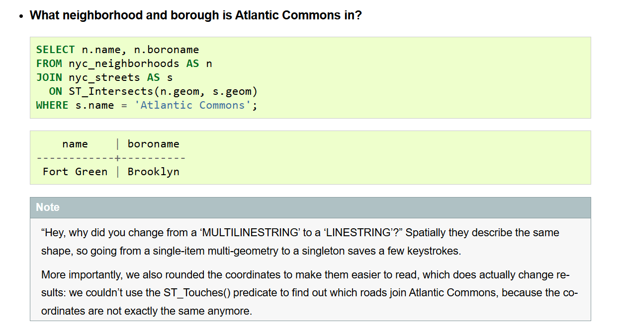
What neighborhood and borough is Atlantic Commons in?
The query is answering a simple spatial question:
Find the street named
Atlantic Commons, determine which neighborhood it intersects, and return that neighborhood’s name and borough.
The key is to understand the query in terms of what each table represents, what is being filtered, and what spatial relationship is being tested.
1. Start with the question
We have two geographic objects:
- Atlantic Commons → a street
- Neighborhood → an area represented by a polygon
So the underlying question is:
Which neighborhood spatially relates to the street called Atlantic Commons?
The borough is then an attribute of that neighborhood.
2. Look at the two datasets
The query uses two tables:
1
2
nyc_streets
nyc_neighborhoods
Think about them like this:
1
2
3
4
5
6
7
8
nyc_streets
├── name
└── geom

nyc_neighborhoods
├── name
├── boroname
└── geom
geom is the geometry column.
Conceptually:
1
2
street geometry       → LINESTRING
neighborhood geometry → POLYGON
So we have a line and a polygon that we want to compare spatially.
3. Find the street we are interested in
This part:
1
WHERE s.name = 'Atlantic Commons';
means:
From the streets table, only consider the feature(s) whose name is
Atlantic Commons.
The alias s represents nyc_streets:
1
FROM nyc_streets AS s
So:
1
s.name
means:
the
namecolumn fromnyc_streets.
At this point, we have identified the street we want to investigate.
4. Find the neighborhood related to that street
This is the important PostGIS part:
1
ON ST_Intersects(n.geom, s.geom)
ST_Intersects() asks:
Do these two geometries intersect?
Here:
1
2
n.geom → neighborhood polygon
s.geom → Atlantic Commons street
So PostgreSQL is effectively asking:
Does this neighborhood polygon intersect the geometry of Atlantic Commons?
If yes, that neighborhood is included in the result.
5. Why do we need a JOIN?
The street and neighborhood information are stored in different tables.
We need:
1
2
3
4
5
nyc_streets
     │
     │  spatial relationship
     ↓
nyc_neighborhoods
The JOIN connects the two datasets based on their location, rather than on a shared ID.
Normally, a SQL join might look like:
1
ON streets.neighborhood_id = neighborhoods.id
But here, the relationship is determined spatially:
1
ON ST_Intersects(n.geom, s.geom)
That’s one of the fundamental ideas in PostGIS:
The geometry itself can be used to establish the relationship between features.
6. Why ST_Intersects()?
Because the question is essentially asking:
Which neighborhood geometry intersects the street geometry?
So the reasoning is:
1
2
3
4
5
6
7
Question
   ↓
Find Atlantic Commons
   ↓
Compare its geometry with neighborhood geometries
   ↓
Find the neighborhood(s) that intersect it
That becomes:
1
ST_Intersects(n.geom, s.geom)
7. What does SELECT return?
The first line says:
1
SELECT n.name, n.boroname
We only want two pieces of information from the matching neighborhood:
1
2
3
4
5
6
7
n.name
    ↓
Neighborhood name

n.boroname
    ↓
Borough name
So the final result might look conceptually like:
1
2
3
name                 boroname
-------------------  --------
Some Neighborhood    Brooklyn
Read the query from the inside out
A useful way to understand this query is to mentally execute it in stages.
Stage 1 — Find Atlantic Commons
1
WHERE s.name = 'Atlantic Commons'
↓
Stage 2 — Take its geometry
1
s.geom
↓
Stage 3 — Compare it with neighborhood geometries
1
ST_Intersects(n.geom, s.geom)
↓
Stage 4 — Keep the neighborhoods that intersect it
↓
Stage 5 — Return their names and boroughs
1
SELECT n.name, n.boroname
Put the whole thing into plain English
1
2
3
4
5
SELECT n.name, n.boroname
FROM nyc_neighborhoods AS n
JOIN nyc_streets AS s
  ON ST_Intersects(n.geom, s.geom)
WHERE s.name = 'Atlantic Commons';
Read it as:
Look at the neighborhoods and streets. Find the street named Atlantic Commons. Then find the neighborhood geometries that intersect that street. Finally, return the neighborhood name and borough.
One important detail
ST_Intersects() means any spatial intersection.
It does not necessarily mean:
“This is the one neighborhood that contains the entire street.”
A street can cross a neighborhood boundary and therefore intersect multiple neighborhoods.
So the query is technically asking:
Which neighborhoods intersect Atlantic Commons?
Whether that is equivalent to:
Which neighborhood is Atlantic Commons in?
depends on the data and the intended interpretation of the exercise.
That distinction is an important part of learning PostGIS: understand what the spatial predicate actually asks, not just what the English question seems to imply.